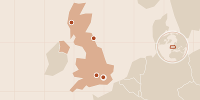
Before Hogwarts there is London: a market alley off Gracechurch Street, a barrier between platforms, a staircase in Oxford, a castle in Northumberland and a steam train crossing a Highland viaduct. This route visits six real places that built the Harry Potter films, shot from September 2000 to March 2001 and returned to in the sequels.
You start where Harry buys his school supplies, run through the wall at King's Cross, climb the stairs down which McGonagall comes to meet him, wake in the hospital wing, take your first flying lesson at Alnwick and ride out over Glenfinnan — six real places, each tied to the scene it created.
The Boshin War ran from Kyoto to Hakodate in eighteen months: the battlefield at Toba, Edo Castle, the hill of Ueno, Aizu's castle and Goryōkaku. In January 1868 the young emperor was declared ruler in fact as well as name, ending more than 250 years of Tokugawa rule, and the last shogun's supporters fought on until a breakaway republic made its last stand.
The route follows that war in six places, all of them visitable: the battlefield at Toba, Edo Castle, the hill of Ueno, Aizu's castle and the hill where its teenage soldiers died, and Goryōkaku. Dates are given in the Western calendar, converted from the Japanese lunar dates used at the time.
In 1791 Saint-Domingue was France's richest colony, a sugar and coffee economy worked by hundreds of thousands of enslaved Africans under brutal conditions. Thirteen years later it was Haiti, the first nation born from a successful slave revolt and the first independent Black-led state in the Americas. The cost was enormous: some 200,000 Black Haitians died, and tens of thousands of French and British soldiers, most of them from yellow fever.
The route follows the turning points, from the ceremony that tradition places at Bois Caïman to the declaration at Gonaïves, with a detour to the French mountain fortress where Toussaint Louverture died. Fighting was savage on all sides, and the texts say so plainly. The route offers no travel advice for Haiti.
In May 1863 a Hamburg professor of mineralogy decodes a 300-year-old note in runes: go down the crater of Snæfell in Iceland and you will reach the centre of the Earth. Within days he drags his reluctant nephew Axel north by train, steamer and schooner, hires a silent Icelandic guide named Hans and climbs into the volcano.
Verne sets up the impossible with a timetable you could almost follow today — Altona station, Kiel, Copenhagen, Reykjavík, the hamlet of Stapi below the glacier. What happens underground is pure fiction, but the way out is real: three months later the travellers are spat out of Stromboli, an island volcano off Sicily, more than 3,000 km from where they went in.
Dracula crosses Transylvania's Borgo Pass and Whitby's harbour, steps and churchyard, then Purfleet on the Thames and London Zoo. A young English solicitor becomes the Count's prisoner; Dracula ships himself to England in fifty boxes of earth and is hunted back to his mountains by Van Helsing's band.
Stoker never visited Transylvania; he built its geography from books and maps, and the English half from places he knew. The route follows the novel's diaries and letters stop by stop: the inn at Bistritz, the Borgo Pass, the Black Sea port of Varna, the harbour, steps and churchyard of Whitby, Purfleet on the Thames, London Zoo and the final race up the Danube at Galatz.
In 218 BC the Carthaginian general Hannibal set out from Spain to attack Rome by the one route the Romans never expected: overland, across the Pyrenees, the Rhône and the Alps, with tens of thousands of soldiers, horses and 37 war elephants. Five months later he came down into the plain of the Po with a battered but unbeaten army, and within weeks had won his first two victories in Italy.
The route follows the march as told by the Greek historian Polybius, who wrote about seventy years later and walked the Alpine route himself. Nobody knows for certain where Hannibal crossed the Rhône or which pass he used, so several pins are marked speculative.