History
In the Footsteps of Jesus: Nazareth to Jerusalem
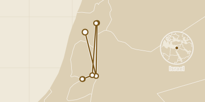
Follow in the footsteps of Jesus through the Holy Land: from the Basilica of the Annunciation in Nazareth to the Jordan baptism site, Capernaum, the Sea of Galilee shore, Jericho, Gethsemane and the Church of the Holy Sepulchre in Jerusalem.
The Gospels name many places but rarely fix a spot, so most stops here rest on tradition. Each is labelled as exact, approximate or speculative, with what archaeology can and cannot show.
Timeline & locations
What do the location labels mean?
- Approximate
- The right area — a town, park or district — but not a precise spot.
- Speculative
- A reasoned guess: sources disagree or the exact place is unknown.
Nobody can prove where the Annunciation happened, and two Nazareth churches claim it. Catholic tradition places it here, where the angel Gabriel appeared to Mary and announced that she would give birth to Jesus; a Greek Orthodox church built around a spring is the rival. The present basilica was built over earlier churches in 1960–1969.
Location precision: Two churches claim the Annunciation, and the Gospels do not name the exact spot; the pin marks the Catholic basilica.
Visitor guidance: Still a working Catholic church in Nazareth.
Sources
- Basilica of the Annunciation (Wikipedia)
- Locator:
- History section
- Basilica of the Annunciation (Wikipedia)
Tradition says Jesus was baptised by John the Baptist on the Jordan's east bank here, a place venerated since at least the Byzantine period. Visitors see the remains of churches, baptism ponds and pilgrim and hermit dwellings. Access was restored only after the 1994 Israel–Jordan peace treaty. There is no archaeological evidence that Jesus was baptised in these waters, so treat it as tradition.
Location precision: The site is venerated by tradition and no excavation proves it.
Visitor guidance: A World Heritage Site on the Jordan side; check entry rules before you go.
Sources
- Al-Maghtas (Wikipedia)
- Locator:
- Introduction; Rediscovery
- Al-Maghtas (Wikipedia)
After leaving Nazareth, Jesus made Capernaum the centre of his ministry in Galilee. On a Sabbath he taught in the synagogue and healed a man, according to Luke and Mark. The synagogue you see is a later building of white limestone, from around the 4th or 5th century, standing out among black basalt houses. Nearby, a 1st-century house became a gathering place, then an octagonal church; a modern church on eight stilts now hovers over it.
Location precision: The ruins are real, but the 1st-century synagogue of the Gospels lies, at best, beneath the later one.
Visitor guidance: An archaeological site on the northern shore of the Sea of Galilee.
Sources
- Capernaum (Wikipedia)
- Locator:
- New Testament; Synagogue; House of Peter
- Capernaum (Wikipedia)
On the northwest shore of the Sea of Galilee, this small church commemorates the moment Jesus reinstated Peter as chief among the Apostles. A projection of limestone rock inside is venerated as the Mensa Christi, the table where Jesus is said to have laid out a breakfast of bread and fish for the Apostles. The church was built in 1933 and includes parts of an earlier 4th-century church; its foundations are visible at the base of the walls.
Location precision: The identification rests on tradition, and whether this table or a second one nearby is the real one is disputed.
Visitor guidance: A church on the northwest shore of the Sea of Galilee.
Sources
- Church of the Primacy of St. Peter (Wikipedia)
- Locator:
- History; Mensa Christi
- Church of the Primacy of St. Peter (Wikipedia)
Going up to Jerusalem, Jesus passed through Jericho. The Gospels say he healed blind beggars here and persuaded the chief tax collector Zacchaeus to repent of his dishonest practices. The road between Jericho and Jerusalem is also the setting of the Parable of the Good Samaritan. The modern town stands in the Jordan Valley, and several sights nearby are traditionally tied to Jesus, including a sycamore tree identified with Zacchaeus.
Open area inGoogle MapsApple MapsOrganic MapsOpenStreetMap31.85605, 35.45982Visitability not confirmedLocation precision: The pin marks modern Jericho; the Gospels do not fix any single spot, and the town has moved over the centuries.
Sources
- Jericho (Wikipedia)
- Locator:
- In the New Testament
- Jericho (Wikipedia)
On the night he was arrested, Jesus went to a place he and his disciples customarily visited, which allowed Judas Iscariot to find him. Four sites at the western foot of the Mount of Olives are claimed by different denominations. Pilgrims have come since at least 333, when the anonymous Pilgrim of Bordeaux visited. Modern scholarship acknowledges that the exact location of Gethsemane is unknown, so the pin marks one of the claimed gardens.
Location precision: Four denominations claim four sites; the pin marks one of the claimed sites at the foot of the Mount of Olives.
Visitor guidance: Gardens and churches at the foot of the Mount of Olives.
Sources
- Garden of Gethsemane (Wikipedia)
- Locator:
- Location; History
- Garden of Gethsemane (Wikipedia)
Since early in the fourth century, this church has been recognised as the place where Jesus was crucified, buried and rose from the dead. Tradition puts Calvary, or Golgotha, up a stairway just inside the entrance, and the empty tomb beneath the rotunda. The church was consecrated on 13 September 335; fires, destruction and rebuilding followed over the centuries.
Location precision: The identification dates to the fourth century and rests on tradition, not on contemporary evidence.
Visitor guidance: A major pilgrimage church in Jerusalem.
Sources
- Church of the Holy Sepulchre (Wikipedia)
- Locator:
- Introduction; History; Calvary
- Church of the Holy Sepulchre (Wikipedia)